 Introduction:
The ability of soaring birds to effortlessly employ air currents to their advantage remains one of the wonders of nature. However, the physical properties of the atmosphere which soaring birds utilize are quite well understood. The purpose of this paper is to provide the reader with an introduction to the meteorology of soaring flight. This will add another dimension to bird watching and allow knowledgeable decisions to be made regarding the best opportunities to observe soaring birds.
In order for soaring flight to be possible there must either be local upward movement of the air or the air must have nonuniform horizontal velocity in space or time. The former includes the familiar thermals and is the focus of this paper. The latter is more usually applied to sea birds and the interested reader is referred to Cone (1962) for a discussion on the subject.
 Definitions and
Concepts:
Before proceeding it is necessary to present a few definitions and concepts. By necessity they will be brief but will allow what follows to be more easily understood.
Moisture holding capability of air:
A unit volume of warm air can hold more moisture than the same volume of cold air. When a unit volume of air is cooled to the point at which it cannot hold more moisture it is said to be saturated. If it is then cooled further, some of the moisture will condense out of the air. That is why we see our breath during cold weather. When we exhale, the air from our lungs is very moist. Once it enters the atmosphere it is cooled. In cold weather the cooling is sufficient for it to become saturated. Further cooling produces condensation which we then see. Clouds are the result of air being cooled below its saturation temperature.
Lapse rate:
An understanding of the term lapse rate is crucial to understanding how birds soar during warm summer days. As one proceeds in a vertical direction either by climbing a mountain or in a plane the temperature of the air normally gets cooler. An exception often occurs in the winter when the lack of solar heat allows very cold air to form near the surface of the earth. Under such cases the temperature may increase with height. This situation is often encountered when skiing in the mountain parks. The temperature on the ski hill may be 10 to 20 degrees celsius warmer than the air at the valley townsite. This rate of change of temperature with height is called the lapse rate of the free atmosphere or more generally, simply the lapse rate. It is constantly changing but the largest changes are associated with the passage of major weather systems.
Dry Adiabatic Lapse Rate:
This is another crucial but not easily understood concept. It is a fact that as air expands it cools. This is the principal of the air conditioner and why a propane bottle cools when in heavy use. Picture a very thin balloon inflated with air which is gradually lifted up through the atmosphere. At the surface let us suppose the balloon has a diameter of 1 foot. Its shape and size is defined by the pressure of the atmosphere pushing inward on it. Because pressure decreases as one ascends in the atmosphere the balloon will gradually increase in size as it rises higher and higher. This means the air in the balloon is expanding and therefore cooling. If no heat from the surrounding air was allowed to enter or leave the balloon, and we could measure the rate of cooling within the balloon we would find that it cooled at a rate of 3 degrees celsius for every 1000 feet it ascended. Therefore if it was at 20°C on the surface and ascended 5000 feet it would cool 15 degrees (5 X 3 ) to 5°C. This is the maximum rate of cooling that is usually observed in the atmosphere and is called the Dry Adiabatic Lapse Rate. This is a calculated value and may or may not equal the actual lapse of the free atmosphere defined above.
Stability and Instability:
Consider the previous described balloon and assume the material of the balloon has no weight but exists only to contain the air. Accepting the fact warm air is less dense than cold air it is then logical that if the air contained by the balloon is warmer than the surrounding air it will rise (this is the principal of the hot air balloon). Furthermore, the parcel of air will continue to rise and cool by expansion at the dry adiabatic lapse rate until it encounters a portion of the atmosphere warmer than itself. At that point assent will end although the parcel will continue drift with the wind field and gradually become mixed into the atmosphere.
A section of the atmosphere which allows the existence of such vertical currents of air is said to be unstable. Conversely, an atmosphere in which the vertical temperature gradient is such that vertical motions, either up or down, are suppressed is defined as being stable. The situation becomes more complicated once condensation begins due to the large amount of heat released by the condensation process.
 Vertical Motion in
the Atmosphere:
Vertical motion within the atmosphere occurs on a number of scales. Large scale assent and descent of the atmosphere such as that associated with major weather systems is often used by birds during migration and is briefly discussed in a later section. Significant changes to daily weather are generally caused by large or synoptic scale weather systems such as the areas of high and low pressure shown on the weather maps in the daily papers and on TV. Embedded within these large scale weather systems, are mesoscale, or smaller scale weather events, some of which will be the subject of the following discussion. Mesoscale systems include thermal updrafts resulting from heating of the earths surface, the wind regime over hills and small mountain ranges, valley and mountain winds, thunderstorms and chinooks to name but a few.
Flow over Obstacles:
When a horizontal flow of air encounters an obstacle whether it be a range of mountains or a stand of trees it has two options: It can either attempt to go over the obstacle or go around it. Only the former will be examined as our interest lies with ascending air over large or small objects.
|
|
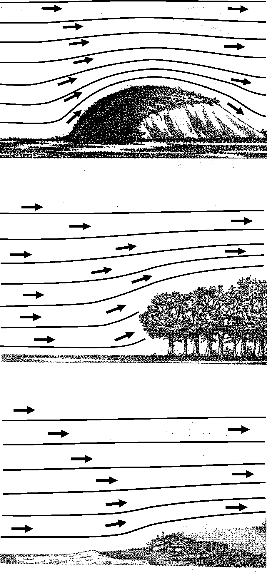
Figure 1 is a modification of diagrams which appeared in Cone (1962) and indicates the type of flow which might be expected to occur when a horizontal flow of stable, non saturated air encounters a small hill, a stand of trees or a beach. The beach does not necessarily have to be associated with an ocean. The lines indicate the direction the air might be expected to take while the distance between the lines indicated the relative velocity of the wind. The closer the lines are together the stronger the wind. In the case of the hill there is a noticeable acceleration near the top of the hill which decreases with height above the hill. There is also an area on the lee side of the hill where the air is descending. obviously not a favourable location for soaring. An increase in wind speed can be noticed on even small hills making them ideal places for kite flying as well as local soaring.
Under certain atmospheric conditions lee or mountain waves develop downwind from a range of mountains or high hills. These will not be discussed here but are well covered in Wallington (1977). For large hills or mountains the keen observer will quickly be able to identify those cases where the air is moist as cloud and rain may form when the air is forced upward. Additionally, if the free atmosphere is unstable, the air forced upward by the mountain will continue to rise and large cumulus clouds, showers and perhaps thunderstorms may form.
A stand of trees does not present an obstacle to the wind however, and a small area of lift will still develop on the upwind side. Air near the surface enters the trees and the energy dissipated by movement of the branches, leaves, etc.
The beach in Figure 1 presents an even smaller obstacle but will still produce a area of local upward motion. However many ocean shorelines rise sharply and strong lift will extend for many miles.
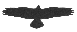
The picture of the three frigates at the top of page 1 was taken along a low shore line
but persistent easterly trade winds allowed the birds to soar for hours without having to
resort to flapping flight.
Dry Thermals:
In order for soaring land birds to scan large areas for food it is necessary for there to be a more general source of lift than that provided by the static objects previously discussed. Fortunately nature has provided such a source in thermal updrafts generated by the summer sun. The following discussion will be limited to the case in which the air remains unsaturated throughout its assent and subsequent cooling. That is, cloud is not observed to form.
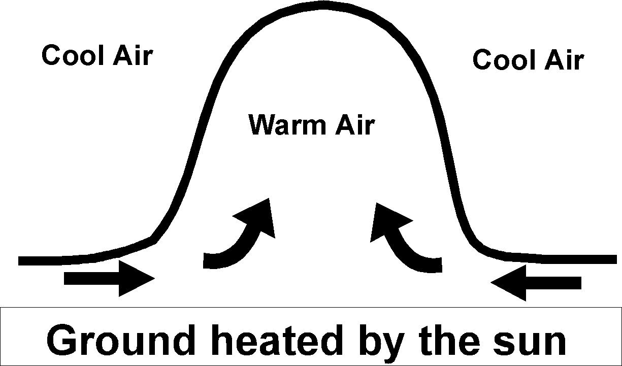
Consider the case of a typical summer morning. Overnight the air near the surface has cooled and can be considered to be stable. As the sun gradually warms the surface, heat is quickly transferred into a shallow layer near the surface. As more heat is added by the sun this shallow layer will eventually become warmer than the air above it and becomes buoyant. A portion of this warm layer will eventually protrude into the cooler air above it and a thermal dome will form. More warm air will quickly begin to flow into the area and the dome will grow as indicated in Figure 2. These domes form in a random fashion much as bubbles form in a pot of boiling water.
As the warm air flows into the dome it begins to rise.
Within a few minutes, the local source of very warm air is exhausted, it pinches off at
the base, and the thermal will rise as a bubble of warm air detached from the surface. The
bubbles or dry thermals will rise until they reach the top of the 'thermal layer', or that
portion of the lower atmosphere having a lapse rate equal to the dry adiabatic lapse rate.
This layer will initially be very thin. However, as heat is added by the sun and
transported aloft by the thermals, the base remains on the surface while the top of the
layer will continually rise during the day reaching 2000 to 3000 feet by early afternoon
and frequently higher depending on how much heat can be added to the atmosphere. This
thermal layer defines the portion of the lower atmosphere in which dry thermals will
exist. As a thermal rises the air within it begins to rotate as shown in Figure 3. The
core of the thermal is filled with the warmest air and also contains the strongest
updraft. As it rises the thermal spreads laterally. Wallington (1977) states that the
thermal will reach a diameter of 500 to 2000 feet when it between 1000 and 2000 feet above
the surface. We are then talking of a area of ascent in the order of 1/3 mile or 1/2
kilometre in width.
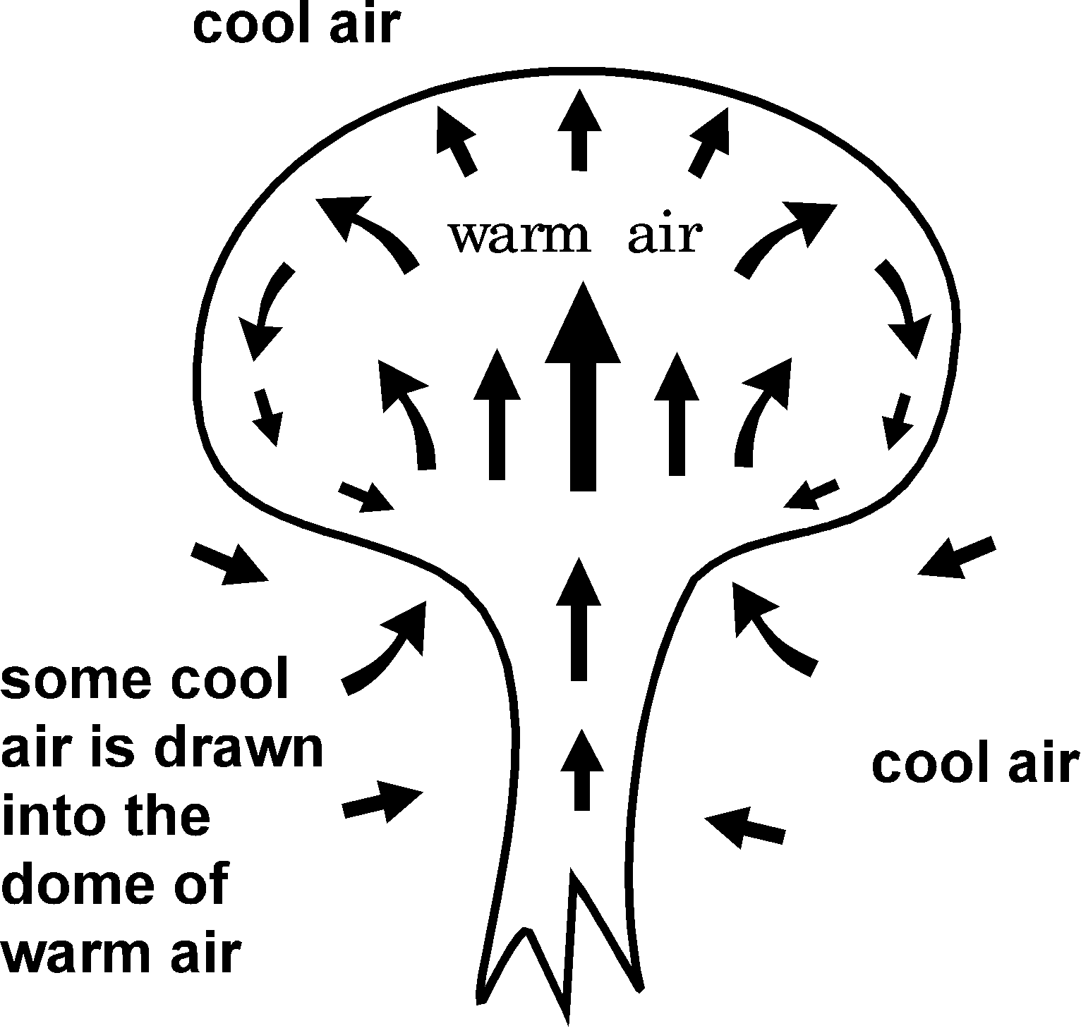
Figure 4 is an attempt to give more detail to the motions
inside the thermal and is based on a model presented by Cone (1962). 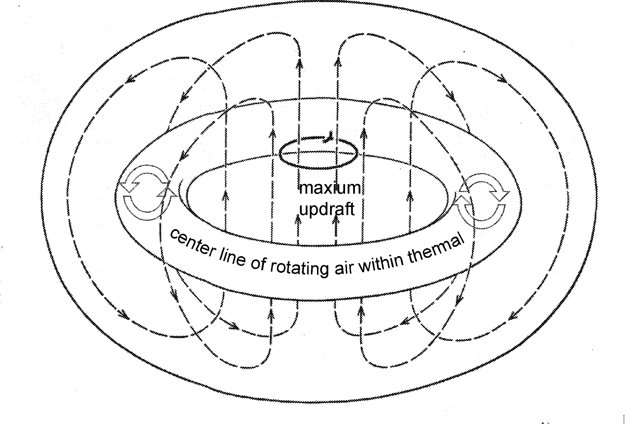 Note that because of the large size of the thermal a bird is able to
soar entirely within the centre updraft.
When examining Figure 4 one must keep in mind that the entire bubble of air is rising and even the areas of downward motion within the bubble may still be ascending relative to an observer on the surface.
Figure 5 shows the lower portion of the atmosphere during a
warm summer afternoon and may aid in understanding a complex 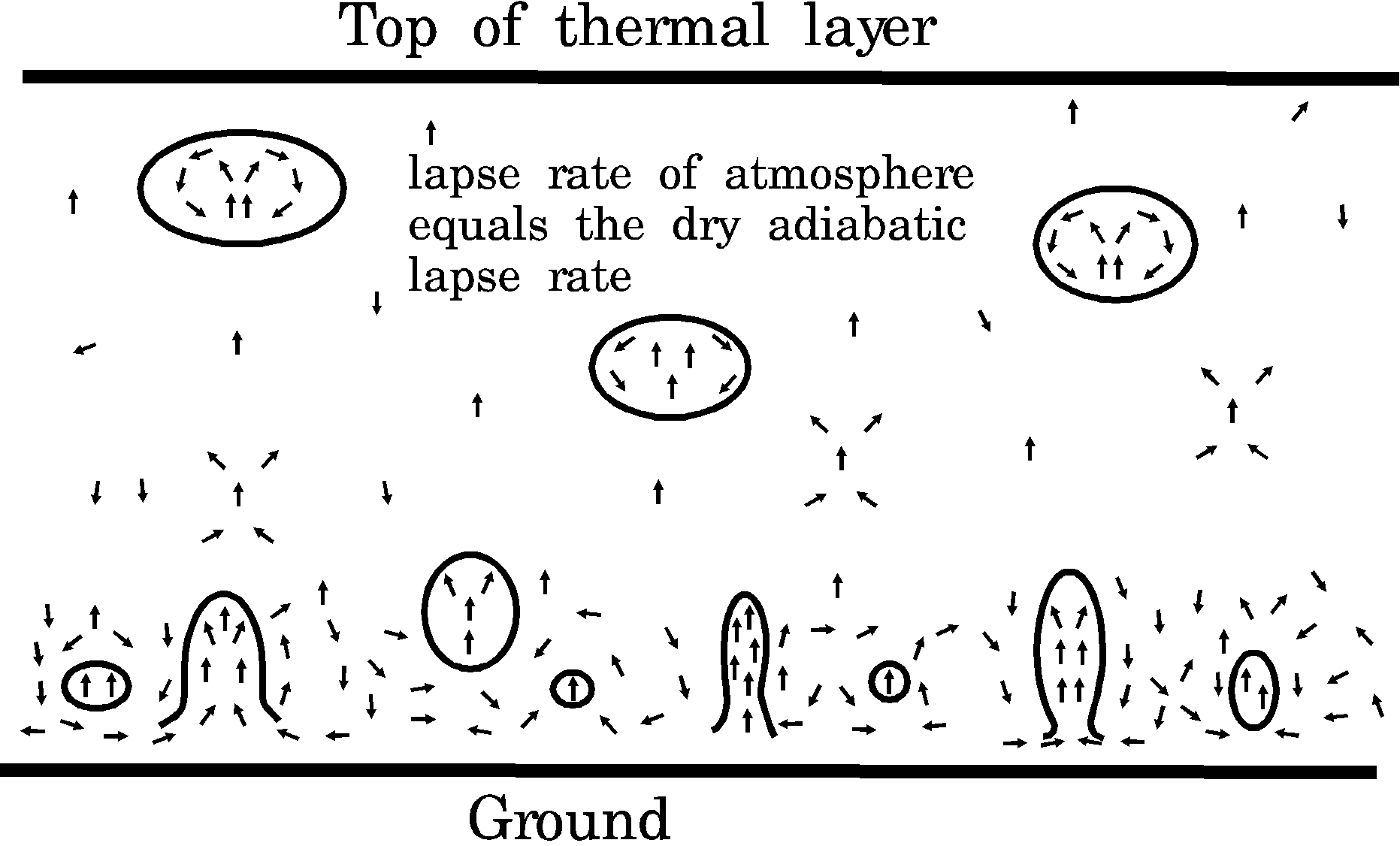 situation. If, during the summer months the weather pattern is not
changing (synoptic systems are not moving across the area), most of heat carried aloft one
day will remain overnight. In such a scenario only a shallow layer of air near the surface
will have to warmed the next morning before strong thermals can redevelop. Anyone who has
flown in small aircraft during a hot summer day can attest to not only the presence of,
but the strength of these dry thermals. They can also make airport approach very
uncomfortable in a large commercial aircraft.
The addition of moisture quickly complicates the situation as considerable amounts of heat are released during the process of water vapour condensing into water droplets. The presence of cloud will mark the location of the individual thermals. Keep in mind that these are not connected to the ground so although one bird may be able to soar within an elevated thermal a similar bird at a lower level may have to revert to flapping flight until it locates another thermal. These type of observations assisted meteorologists in developing the theory of thermals.
 Migration of
Soaring Birds:
Heintzelman (1986) presents a diagram which shows strong correlation between cold frontal passages and fall hawk migrations over Nevada. He also sites other studies which link fall migrations with the passage of cold fronts over the eastern provinces and states. The reason being that an area of assent develops along most cold fronts and moves southward with the front. Additionally, persistent northerly winds normally follow the passage of cold fronts and the still warm earth heats the colder air producing thermals. The literature examined did not contain examples from western Canada but a similar situation may exist. A logical extension of the previously discussed isolated hill is a range of hills or mountains. The Appalachian Mountains extend in a northeast to southwest line and with prevailing westerly winds the various ridges and mountains that form the Appalachians serve as hawk migration routes (Heintzelman, 1986).
The spring northward migration is not so easily correlated with weather conditions but warm southerly winds have been shown to produce hawk migrations over eastern Canada and northeastern U.S.
The circulation around an area of high pressure is clockwise and counterclockwise around an area of low pressure. Given the above, the large scale or synoptic weather pattern which would produce such a flow east of the Rockies is an area of low pressure over southern British Columbia and higher pressure over Saskatchewan and Manitoba. If an area of high pressure is pushing southward through the northern prairies it is likely to generate northeast to easterly winds over central Alberta; an unfavourable condition. As it moves southward into the east central prairies winds will swing into a more south to southeasterly direction which should be more favourable. Major storms moving eastward into Alberta are likely to produce cloud and possible precipitation which may suppress migration. On the other hand relatively weak systems tend to deposit much of their moisture on mountains while producing light to moderate southerly winds east of the mountains while patchy or thinner cloud cover will still allow thermals to develop. The passage of such systems is often marked by a rapid shift to a west or northwest wind.
 Summary:
Soaring birds may use rising air currents produced by objects such as hills, bluffs, stands of trees, mountain ridges, etc for static soaring. Soaring birds will also use the lift produced by properly oriented ranges of hills or mountain as a migration.
Thermals which develop during light or moderate wind conditions present a method for soaring birds to move quite freely over large areas.
Studies show that at least over eastern North America the passage of a cold front will trigger a fall southward migration.
In western Canada, spring migration most likely depends on a southern flow of air produced by large scale weather systems. It would be enhanced by the presence of thermals. Such conditions most often develop with the approach of an area of low pressure from the west and, or, the location of higher pressure over the southern portions of Saskatchewan and Manitoba.
Finally, although the information presented in this paper should allow the complete local public forecast to be interpreted so that the most favourable soaring days can be identified it will not replace a few hours spent studying a good book on basic meteorology. Such books are available at most local libraries and if not can be obtained on inter library loans. The Flight Strategies of Migrating Hawks by Paul Kerlinger and Meteorology for Glider Pilots by C. Wallington are recommended. The books by Wallington and Heintzelman and paper by Cone are available through the Edmonton Public Library.
 Bibliography:
Cone, Clarence D., 1962: The Soaring Flight of Birds.
Scientific American, April.
Heintzelman, Donald S., 1986: The Migration of Hawks.
Indiana University Press.
Kerlinger, Paul, 1989: Flight Strategies of Migrating
Hawks. The University of Chicago Press.
Sutton, O.G., 1960: Understanding Weather. Pelican
Books.
Wallace, John M. and Peter V. Hobbs, 1977: Atmospheric
Science, Academic Press.
Wallington, C. E., 1977: Meteorology for Glider Pilots.
J. W. Arrowsmith Ltd.
