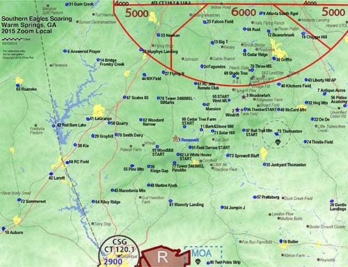
Turnpoint Maps Map of Local Turnpoints Zoomed In warm_springs_map 2015 SeeYou Zoom local Dark background Detailed Map of All Turnpoints warm_springs_map 2015 SeeYou full
Simple Map of All Turnpoints
USGS Topomap of Warm Springs area |
|
Turnpoint List Full List The Warm Springs Turn Point file has 90 turn points, including those needed for FAI Triangles, as well as Out & Return flights for Records & Badges. There are close in turn points for teaching cross country to students, while staying close to home. It has 595 total points. 90 turn points. The rest are non turn points = 505 for landouts! We've realized that often when that really great day comes a pilot's imagination is limited by the waypoints loaded into their GPS ...so we have expanded boundaries to allow for exceptional flights when the opportunity arises. This list was also generated with the intention of using it for the 3 local gliderports: Roosevelt, Meadowlark & Windrift. Downloadable files are on the Turn Point Exchange: http://soaringweb.org/TP/Warm_springs
Alternate "shorter" lists for older Cambridge flight recorders and other "Jurassic GPS" systems. Use this only if you prefer a smaller file with few turn points. You are welcome to use these, or cut your own down from those on the TP exchange server. Files are zip compressed. Less than 250 points. Sufficient for all GTA contests. Goes out to ~97miles. warm_springs2015nm_web245.cup SeeYou .Cup 245 points. warm_springs2015-242.dat CAI formatted .dat file with 242 points.
warm_springs2015nm_web495.cup
Disclaimer We've put considerable effort into checking the points in the database we've distributed. In doing so, we've made numerous corrections that are likely to be helpful (such as eliminating some airfields that are not safely landable, and correcting coordinates that were wrong). Unfortunately, we are confident that perfection has not and cannot be achieved. We will neither withhold useful information from pilots, nor accept responsibility for any decision that properly belongs to a pilot in command, including that of evaluating the safety of any potential landing site. No landing site whether an airport or otherwise can be deemed suitable or available other than the pilot in command.
|
Tasks Plan your own adventure, some ideas are on the task page |
Back
to SES homepage
Last modified
24-Aug-2015
by CR